As the world becomes more conscious about the impact of the way we operate and consume nature’s resources and more focused on sustainability, it is becoming increasingly clear that location technology has an important role to play in achieving sustainability goals.
From optimizing transportation to identifying the best locations for renewable energy infrastructure, location technology has the potential to revolutionize the way we approach and solve environmental challenges.
From the very beginning, at UNL, we have been committed to contributing to a more sustainable, resilient, equitable, and inclusive world. We began with the mission to enable more than 4 billion people without an address to take part in the daily economic traffic.
Today, our micro-location technology enables solutions, companies, and business models that contribute to UN SDGs, including:
The past years have brought explosive growth in ecommerce orders, delivery, and convenience models. With this, more and more delivery vehicles are being sent out, contributing to higher congestion and CO2 emissions.
The last mile is notoriously famous for being the most inefficient step of the supply chain. Solving this inefficiency is a complex challenge with many dynamics that vary across geographies, such as accuracy of addressing and geocoding, up-to-date POI data, vehicle type, road conditions, weather, real-time traffic, and more.
We developed a suite of powerful location services, hyperlocal data, and mapping tools to give businesses of any size control over the last mile – from check-out to door. For example, delivery and mobility companies can use UNL micro-location technology and services to optimize fleet planning and management, resulting in fewer cars on the road and less trips needed.
Companies can also create their own Virtual Private Maps, where they can bring, manage and leverage various data sources to feed UNL location services (including geocoding, search, discovery and routing) with up-to-date and rich location data. This, includes their own business data, such as driver knowledge, en-route and POI insights, contextual pick-up and drop-off points, customer contributions, etc.
All data is embedded into the UNL Routing Engine, resulting in highly optimized routing, leading to shorter routes, higher efficiency and less emission in the last-mile and last-meter.
Clean transportation plays a crucial role in achieving sustainability and net-zero emissions. UNL is working together with India’s National Highway for Electric Vehicle (NHEV) to geofence the Jaipur-Delhi-Agra E-highway and bring a state-of-the-art EV-ready infrastructure which will help NHEV run electric vehicle fleet on this e-highway using Anti Theft System (ATS).
For this, UNL is facilitating the creation of a custom Virtual Private Map to digitize and accurately map point of interest data, including EV Charging Stations, bus stops, taxi pick-up and drop-off points, road signages, accident-prone points, various vehicle speed information, toll information, and emergency services. By digitizing the e-highways and capturing POI information, UNL is enabling the calculation of more optimum EV-specific routes, taking into account EV charging stops to reduce range anxiety.
E-vehicle drivers receive real-time notifications for the nearest charging station, ensuring convenience and efficiency. VPMs enhance tracking, provide SOS support for e-vehicles, and improve last-mile logistics navigation, reducing fuel costs and emissions.
As the urgency for adopting more sustainable ways of consumption and production is rising, location-technology is going to play a more prominent role in how we rethink and reorganize across industries beyond logistics and mobility.
We have designed the UNL Platform as an industry agnostic, do-it-yourself, and low code solution. That means that small size companies across industries can leverage UNL plug-n-play location services, and widgets to power innovation, start lean, move fast and quickly bring to market new solutions and test new business models.
Today, UNL technology is powering start-ups and scale-ups across industries, including insurance, on-demand drone deliveries, ride-sharing EV solutions, climate change and carbon capturing solutions, and digitization and preservation of nature assets.
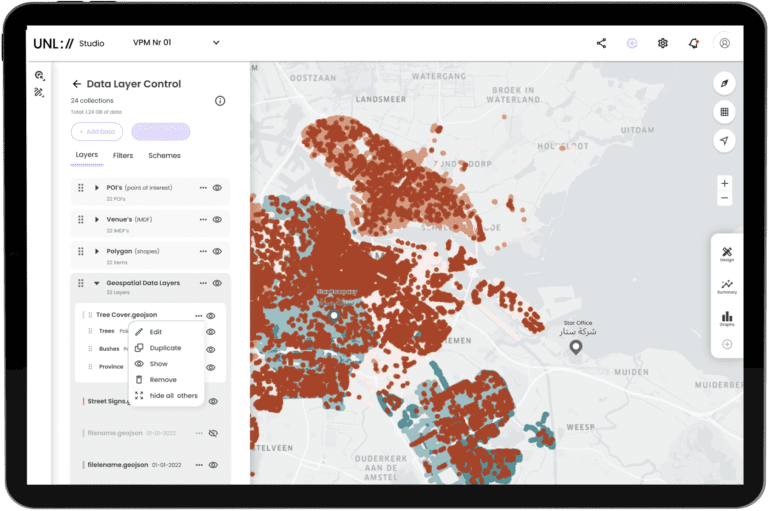
One such startup is RetreevAIble, which is digitizing urban nature assets and develops impact assessment and investment tools to fund, manage and maintain portfolios of nature-based solutions.
RetreevAIble is leveraging UNL Core technology, including UNL 3D Smart Grid and Studio capabilities to digitize trees, link tree datasets and dynamically maintain and visualize data using multiple schemes which can be configured at attribute levels, such as static and temporal attributes of tree species data. This includes providing individual tree data of tree species, feature and scenario analytics on tree health, biodiversity, and the environment to third parties to support collaboration between multiple stakeholders, individual contributions, and decision-making for urban tree planning.
Measuring, Reporting, and Verification (MRV) is an essential component in tracking, quantifying, and demonstrating the effectiveness and impact of environmental and social impact of sustainability initiatives.
However, challenges such as lack of reliable data collection infrastructure, data complexity and lack of standardization, data validation, and high costs in collecting and verifying sustainability data, make it difficult to capture and administrate impact in a transparent, effective, and scalable way.
Leveraging UNL Smart Grid Infrastructure we can contextually and hyperlocally link and store sustainability data and associated attributes to UNL geocells and visualize, maintain, and analyze data over time via the UNL Studio.
Additionally, by connecting various data sources like satellite imagery, we can compare the sustainability data to other sources and simplify the validation of results, creating evidence-based proof of impact behind initiatives, including carbon capturing.
In conclusion, location technology, hyperlocal data, and capabilities to capture and represent the world in real-time will be essential for enabling sustainable practices and behaviors, and in achieving sustainability goals. We are yet to discover the magnitude of impact location technology would play as novel concepts, technologies, and business models arise. At UNL, we are committed to democratizing the location technology space and empower more and more companies and individuals to innovate and help bring the world closer to a more sustainable future.
Our Team can help you with:
Our Team can help you with:
Fill in your details and we’ll get back to you in no time.